It would be cool to be able to use geoviews to visualize this global terrain data available as a WMTS tile service on AWS. The data sources vary in resolution, but apparently it’s down to 3m over much of the Arctic and the coastal US!
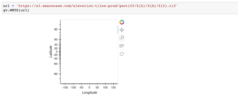
I tried this but it just gives a blank map:
import hvplot
url = 'https://s3.amazonaws.com/elevation-tiles-prod/geotiff/${Z}/${X}/${Y}.tif'
gv.WMTS(url)
I can’t tell, but I’d guess it’s a matter of constructing the right URL string. Here’s one that works:
As written, your version has dollar signs that lead to file not found errors that you can see by opening the browser’s JavaScript console:
But even after fixing the dollar signs the files still can’t be loaded, though the error message is different (and not helpful):
Actually, if I load the URL that it’s trying directly, https://s3.amazonaws.com/elevation-tiles-prod/geotiff/1/1/0.tif , it does load. Maybe Bokeh doesn’t support TIF? If so there may be a PNG or JPG version at that site, given that the tile path says geotiff (suggesting there may be other formats).
Alas, I don’t see any other formats listed in https://s3.amazonaws.com/elevation-tiles-prod, suggesting that it may indeed be down to getting Bokeh to support GeoTIFF tiles (in which case please file an issue with Bokeh).